Tips to turn digital map app into a decision-making tool for regenerative grazing practices
Track grazing paddocks and management moves in Google Earth as a self-guided journey to good grazing.
A ranch map might be viewed as a guide to what you’ve got: a simple, visual reference to known information. But Josh Gaskamp, Noble Research Institute regenerative ranching advisor and manager, suggests enlarging your view of mapping tools.
“A lot of ranchers who want to introduce more regenerative grazing practices want to start with a grazing plan. Some people are big planners, so that fits them,” Gaskamp says. “But some people are journalers, and when you start to journal your grazing on a map, it turns that map into a decision-making tool.”
The difference, he says, comes down to what suits your personality and gets you closer to your grazing goals.
“For me, having a bunch of moves planned out ahead feels too prescriptive – I get stuck on what I said I was going to do, rather than observing the forage for what I should actually do in the moment,” Gaskamp says.
Instead, he’s found guidance in using digital mapping software to track and journal his grazing decisions and observations. Using an application like Google Earth as his guide, he uses his recordings to make decisions for the future.
FIND THE RIGHT APPLICATION FOR YOUR RANCH
There are many options to choose from, ranging from paid, grazing-specific software and applications to geo-spatial maps, mapping apps, measuring software – there’s an app and a tool for about every need you might consider. Gaskamp says if you haven’t used a digital mapping tool on the ranch before, the simplest place to start is likely with a free tool you’re already accustomed to.
Google Maps is almost ubiquitous to most cell phone users. Google Earth is the next level of 3D mapping that uses satellite imagery from around the world. Google Earth can be downloaded for free from the app store on your smart phone or accessed on a computer at www.earth.google.com.
“There are numerous apps out there you can use to do this,” Gaskamp says. “I usually recommend Google Earth as a place to start because it’s simple. Most people have already used Google Maps or have a Google account, so it takes next to no training.”
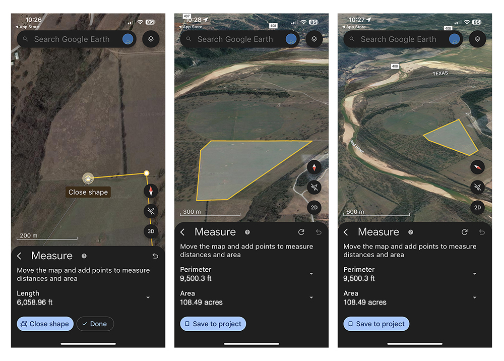
START WITH THE TOP THREE TOOLS – POLYGON, PINPOINT, MEASURE
One of the benefits of a tool like Google Earth is its ability to transfer mapping data across platforms – from your smart phone to your computer to printing out an analog version of your mapping records. While the primary function of the software is available both on the phone app and on your computer, Gaskamp says he often finds it easiest to start by setting up the original map on the computer, where he can use more precise mouse clicks.
Either way, start by locating your property on the map. You’ll need a Google account in order to start and save a new project, which is where the following mapping additions will be filed. Experiment with different views and basic layer options – turn on 3D views or longitudinal grid lines – then look at the three primary tools on the toolbar.
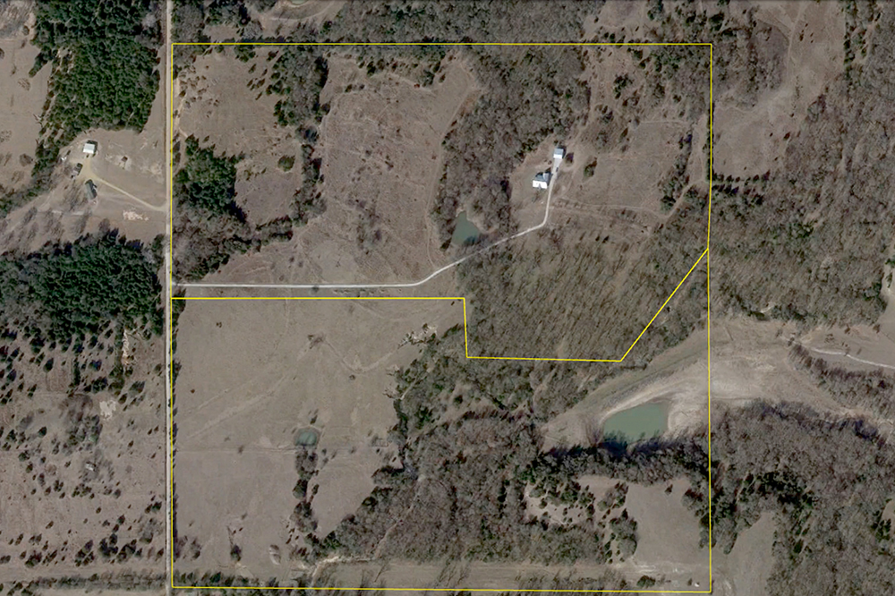
1. Use the path or polygon tool to outline the boundaries of your ranch.
Experiment using the different options for colors and shading. Gaskamp suggests using one color for the primary boundary, then use another color to start marking permanent fences. Each new polygon shape can measure the perimeter distance and the area inside the perimeter.
As he builds temporary fences, Gaskamp marks the grazing area with yet another color and saves the polygon, named by the date he moved livestock into the paddock. In the polygon’s description, he may record pasture conditions on the date of move-in, how many animals he moved, what water or weather conditions were, and any other observations.
2. Use the pin or placemark tool to note existing infrastructure.
Most useful would be water sources, but other buildings, gates, power sources, fencing or utilities might also be of note. Add a description and change the color and size of the markers – say, denoting the capacity of different waters sources with different colors. Click ‘+ media’ to add photos of the location. This might also be a place to mark grazing exclosures or observational sites, saving photos of those locations along with monitoring notes and dates.
3. The third primary tool in the Google Earth toolbox is the measurement tool.
Measure distances to determine fencing needs, calculate grazing areas, measure the distance animals must travel to water sources and more.
USE EVERY ACRE OF THE RANCH, WITH THE MOST EFFICIENCY
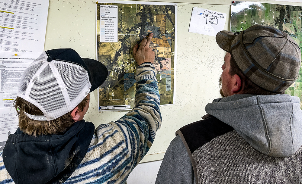
On his home ranch, Gaskamp uses the visual representation of his grazing history to make sure his sheep have covered every grazeable acre in his quick-moving, adaptive grazing system.
“It really paints a picture when I turn on all these polygons and see, ‘I still need to graze over there,’ or ‘I’m missing an opportunity here.’ There are places that maybe I’m not grazing because it’s harder for the animals to get to it, or I just don’t like building fence in that particular area,” Gaskamp says.
Regardless of why the area isn’t shaded into the grazing log, seeing it on the map creates a stark reminder: “To be most profitable, I want to utilize every single acre on the ranch.”
If you’re in the early planning stages of developing a pasture or grazing plan, the measuring tools on a digital map might be a good place to start.
“We know from research that animals will only travel so far for water,” Gaskamp says. That varies depending on terrain, environment and livestock characteristics. Research how far you think your animals might travel on average, then use that as a guide to evaluate pastures.
It’s likely that forage beyond that distance is underutilized, and the grazing land closer to the water sources are overused. Use the map and those measurements to start planning how to use fencing or new water sources to more evenly distribute grazing patterns.
“By journaling it on the map, I ensure that I’ve hit every grazeable acre on my ranch, and that I’m using it most efficiently so I can also offer the longest rest periods possible,” Gaskamp says. “That’s how we start to utilize every acre, which increases the carrying capacity of the ranch.”
GET HONEST ABOUT YOUR GRAZEABLE ACRES
The up-to-date satellite imagery of a digital map provides a valuable view of how much of your land is actually grazeable.
“It doesn’t seem like much, but once you start studying that map and take away the couple acres your house and yard sits on, the roadway and ditch, the area that’s getting covered up by brush encroachment or is underwater part of the year – it all adds up,” Gaskamp says. “You start to realize you’ve been stocking for a 90-acre piece of land that really only has 70 grazeable acres.”
Google Earth Pro offers the additional feature of historic images. Google Earth Pro is also free, but requires a software download from your computer’s web browser. If you use the Pro version, look under ‘view’ to select ‘historic imagery.’
“There, you can really see changes in your land over time,” Gaskamp says. “This can offer some big ‘ah-ha’ moments.”
Maybe Grandpa calculated his stocking rate accurately based on 90 grazeable acres, but over time, timber or brush encroachment ate away at that number, and the next generation never made the proper stocking adjustments.
Studying these changes and the current reality can help calculate truly grazeable acres so you can stock your ranch appropriately. It can also help you make a more concrete plan if you need to control brush, change grazing strategies or both to re-gain some grazeable acres.
“Journaling like this significantly changed my operation,” Gaskamp says. “I’m journaling on these maps to learn. I’m journaling to help me make decisions next time I come back to that portion of the ranch. I’m journaling to keep track of animal health, animal behavior, forage quality, and I’m putting it into this digital map form so I have a really good visual representation of what I did, and how I can keep improving.”
Laura Nelson
Laura Nelson, Content Writer
Comment